The Maltese Road Network
Post written by Perit Mark John Scicluna.
“Excellence is doing ordinary things extraordinarily well.” - John W. Gardner
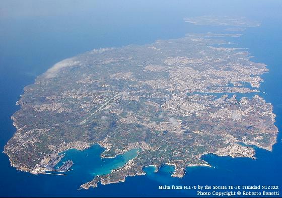
The Republic of Malta, is an archipelago in the middle of the Mediterranean sea, c. 93km south of Sicily and c. 288 km east of Tunisia. As of the 2007 census, there are c. 410,290 inhabitants on the 300 sq. km island, making it the most densely populated country in the European Union (EU) and the seventh mostly populated country in the world with c. 1367 inhabitants / sq. km.

Birds eye view of the Maltese archipelago. Photo courtesy of Roberto Benetti.
Vehicle Ownership
Public transport and personal private vehicles are the only available modes of transport on the mainland. With the public transport service leaving a lot to be desired, the general public had no other option other than to invest in private vehicles as their main mode of transport. With c. 750 vehicles per 1000 persons, Malta has become one of the countries in the world with the most number of vehicles per capita. This value tends to increase yearly.
With more than 300,000 vehicles on the Maltese road network:
- The amount of parking spaces is usually not enough.
- The air quality in the most trafficked areas decreases,
- The amount of traffic accidents is still high.
- Noise pollution increases.
Road Network

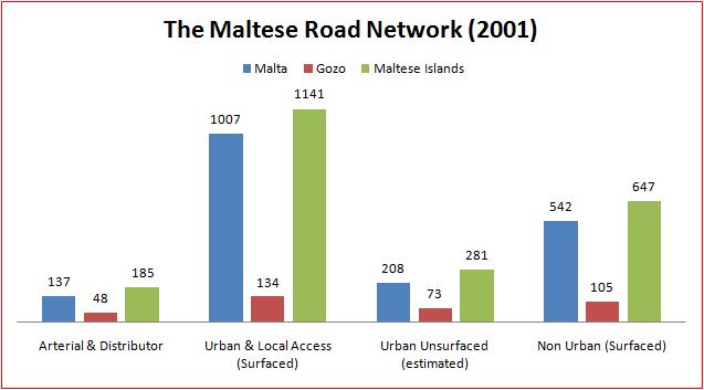
Road Length by Category NSO 2001
Arterial Roads
The backbone of the Maltese road network consist of nine arterial roads forming 185km of paved arterial and distributor roads, with 137 km of arterial and distributor roads located in Malta and the remaining 48 km found in Gozo.
Out of 185km of arterial and distributor roads, c. 90km are arterial roads. These are numbered from 1 to 9 for identification purposes:
- Arterial route number 1 forms part of the Trans European Road Network (TERN) and extends from the south east part of the Malta to the north west part of Gozo, and joins Birzebbuga to Dwejra. It passes via Hal Far, Marsa, Santa Venera Tunnels, Kappara Junction, Coast Road, St. Pauls Bay Bypass, Mellieha Bypass, Cirkewwa, Mgarr Gozo, Victoria, San Lawrenz, Dwejra. The route consists of c. 40.5km in Malta and c. 13km in Gozo.
- Arterial route number 2, 3 and 4 are located in Gozo and are c. 6km, 3.6km and 1.7km long respectively.
- Arterial Route number 5 is c. 5km long and starts from the University roundabout at Tal-Qroqq, passes through Birkirkara Bypass and ends at Mosta.
- Arterial Route number 6 is c. 2.6km long and connects Marsa, Floriana and Valletta.
- Arterial Route number 7 is c. 9.6km. It consists of Mriehel Bypass and Mtarfa Bypass.
- Arterial Route number 8 is c. 7.9km. It starts from St. Lucia Roundabout and passes through Luqa (in front of Barracks), proceeds to Qormi.
- Arterial Route number 9 is c. 6.2km and consists of Gudja Bypass, Ghaxaq Bypass and Tal-Barrani Road.
Distributor Roads
There are c. 95km of distributor roads in the Maltese Road network. Distributor roads connect the arterial roads with the urban roads with linking function. They are numbered from 10 to 99. Such road category includes Marsascala Bypass (denoted as route 26), Valletta Road in Zurrieq (denoted by route 31).
Rural and Urban Roads With Linking Function
These roads:
- amount to c. 196km,
- serve as links between arterial and distributor roads,
- serve as main routes to important touristic attractions and routes,
- reduce community severance.
- are numbered from 100 onwards.

The Maltese Road Network Graph NSO 2001
Categories: Road Engineering
Tags: Road Engineering
Comments: No Comments.